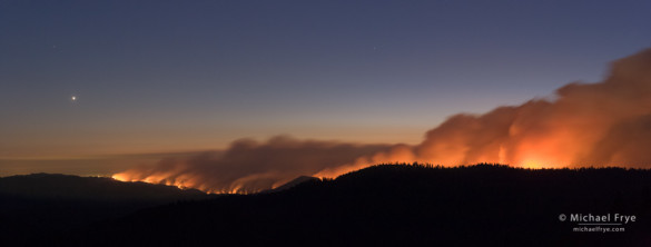
Looking west at the Rim Fire from near the Tioga Pass Rd. at dusk, with Venus setting, 8:57 p.m., 8/22/13, Yosemite NP, CA, USA
Last night my wife Claudia and I made an epic bushwhack to a dome near the Tioga Pass Road with a view of the Rim Fire. This is a two-image stitched panorama, looking west toward the Central Valley, with Venus setting on the left. Each frame was 30 seconds long.
This fire is growing at an alarming rate. It doubled in size yesterday, and as of this morning it was listed as over 105,000 acres. That already makes it the 19th-largest fire in California history. The Rim Fire crossed the western boundary of Yosemite National Park yesterday between Camp Mather and Eleanor Lake.
So far most of Yosemite hasn’t been affected. The smoke has been blowing north, away from the park. The biggest affect is the closure of Highway 120 outside the park, but there are alternate routes.
Let’s hope that growth slows down!
— Michael Frye
Related Posts: Adapting to Fire; Close to Home
Michael Frye is a professional photographer specializing in landscapes and nature. He is the author or principal photographer of The Photographer’s Guide to Yosemite, Yosemite Meditations, Yosemite Meditations for Women, and Digital Landscape Photography: In the Footsteps of Ansel Adams and the Great Masters. He has also written three eBooks: Light & Land: Landscapes in the Digital Darkroom, Exposure for Outdoor Photography, and Landscapes in Lightroom 5: The Essential Step-by-Step Guide. Michael written numerous magazine articles on the art and technique of photography, and his images have been published in over thirty countries around the world. Michael has lived either in or near Yosemite National Park since 1983, currently residing just outside the park in Mariposa, California.
Did you like this article? Click here to subscribe to this blog and get every new post delivered right to your inbox!


Nice image, Michael! Worth the bushwhacking.
It is really scary how quickly this fire increases in size. I hope it gets under control soon.
Thanks very much Daniel. It’s easy for you to say it was worth it, ’cause you didn’t have to do the bushwhacking, and navigating back to the car in the dark! 🙂
It is really scary how quickly this fire continues to grow. I haven’t seen anything like it around here, though it’s happened other places.
Keeping our fingers crossed that somehow it can be slowed down or contained quickly. We are surrounded by fires here in Yakima, and at times it has been pretty smoky. Been going on for quite a few weeks now, and a few days ago a new fire cropped up, so more smoke being added from a different direction. So, almost no matter which way the wind blows now, we get some. The largest, the Colockum Tarps Fire, is now almost totally contained after burning over 125 square miles since July 27. But other smaller ones seem to take it’s place.
So, wishing the fire fighters well in there seemingly impossible task.
Aram, it’s not fun being in smoke all the time, though the smoke can sometimes provide good photo opportunities. And the firefighters do seem to have an impossible task. When a fire really gets going the best they can do is protect some structures, and maybe contain the less active sides. Otherwise they need help from the weather.
Look from space, the smoke cover quite a large area: http://rapidfire.sci.gsfc.nasa.gov/imagery/subsets/?subset=AERONET_Fresno.2013235.aqua.1km
Lake Tahoe seems covered in smoke.
Thank you Michael, for the info and photo – super work. And thank you Enrico for point us to the NASA site for the picture from space. Too many fires in the last few years destroying too much beauty.
Enrico, I’ll second Greg’s thank you for the link. If you look at animated visible satellite weather images you can see the smoke plume clearly, and what was striking today was how wide an area the smoke was emanating from, showing just how big the fire is.
And Greg, thanks!
An enthralling image, Michael. Beauty and horror together. Here in Australia we know only too well what images like these mean. I join you hoping for a speedy end to it.
Thank you Geoff! Places with dry climates, or dry seasons, have fires — I guess it goes with the territory.
Michael, important and moving. Thanks for making the trek and for telling the story. It is a startling and sad occurance which depicts changes in the west and in our climate, all of which are opportune for photo-journalistic reporting. HP
Thanks Hank!
This picture is hauntingly beautiful. I think I understand your mixed feelings about photographing fires. I think about chicks have yet fully fledged, all the creatures unable to escape. Venus above is a calming force, a great catch!
Thank you Sharon. You’re right about Venus, it was a lucky addition to the photo. It helps balance the bright area on the right side, and, as you say adds a sense of calm, serenity, timelessness, which perhaps helps to put the fire in perspective and balance the photo in an emotional sense.
Thanks for the image, Michael. I find myself with my usual split emotions on this: on the one hand, I know that this is the natural cycle for our part of California, and that in a way we’re paying the price for years of misguided fire suppression. On the other, I have friends who had to evacuate from Pine Mountain, others who had to get out of the Lumsden camp on the Tuolumne, and some in Twain Harte who are biting fingernails, so I can appreciate the fear and horror of it as well.
A lot to pull from one image.
Eric, I understand the split emotions — I have them too. Fire is awesome, powerful, necessary, and unavoidable, but also fearsome, especially when you or someone you know is affected.
Hi Michael,
The IncWeb is having technical problems, do you know if the fire is approaching the valley? It’s getting really frightening now.
— I left the same question on another website by accident.
Fire is far away (10miles and more) from the valley. Hwy120 to Crane Flat from the Valley and Tioga Road is open. Hwy120 West entrance remains closed.
Thank you!!
Looking through the picture collection here: http://www.usatoday.com/picture-gallery/news/2013/08/14/wildfires-scorch-the-west/2634797/
Firemen are actually making fire (burning the ground) I assume that is to reduce fuel for the fire spread further.
Enrico, I didn’t see the picture, but they are probably back-burning. When wind conditions are right they set a fire to burn toward the main fire. If successful, the back-burn consumes all the fuel in the main fire’s path and stops it’s advance.
Just a beautiful image Michael. I hope that the fire has slowed or stopped altogether.
Thanks Edith. Not stopped, but it has slowed — see my latest post from today.
Wow, Amazing capture. Hopefully not too much damage Thanks for sharing.
Thanks Ryan!
Michael,
Planned on staying at the Evergreen Lodge in Groveland Sept 9th thru 13th, but had to cancel because of the fire. Instead, we’ve booked the Houndstooth Inn in Oakhurst. Do you think we’ll still be able to get into the park and view the “iconic” scenes?
Art, yes, you should have not problem getting into the park and viewing the iconic scenes. Route 41 between Oakhurst and Yosemite Valley is open, and Yosemite Valley has gone back to being smoke-free after a couple days of heavy smoke. The fire is now 60% contained.
Any chance your pictures of the rim fire will be made available as posters? They are amazing! Ed
Thanks Ed. I don’t think they’ll be available as posters, but they are available as prints. Sizes and prices would be the same as any of the images here:
https://www.michaelfrye.com/port/yose/yosemite1.html
Just click on any of the thumbnails to see details.