Storms have been rare in Yosemite during this dry winter. But on Monday evening a small, cold weather system moved down the coast and brushed the area.
I set my alarm for 4:00 a.m. Tuesday morning to check on the weather and see if it might be worth driving up to Yosemite Valley. We had about three inches of fresh snow at our house in Mariposa, but Yosemite hadn’t received much precipitation – less than a tenth of an inch. Most of the rain and snow with this system fell further west.
I thought about going back to bed, because usually such small amounts of precipitation don’t generate much mist. But on the other hand, whatever did fall in Yosemite Valley was probably snow, so there might be a dusting on the trees. Also, clouds and showers had lingered through most of the night, and temperatures in Yosemite Valley had stayed around 32 degrees – both positive signs. If skies had cleared during the night, and temperatures fallen below freezing, there would be no mist, as mist development requires unfrozen moisture.
I decided to go and take a chance. The worst that could happen is I would lose some sleep. Claudia decided to come with me.
When we arrived in Yosemite Valley we found about an inch of snow on the ground, and, surprisingly, lots of mist. We drove up to Tunnel View, but there was no view at first; it was completely socked in. But there was a good chance that the mist would open up at some point, so I decided to wait. We ran into our friend Charlotte Gibb, and Charlotte and I chatted while shivering in the cold and waiting for breaks in the clouds. A dozen other hardy souls waited with us.
I’ve made many photographs from Tunnel View, and from all the other classic viewpoints in Yosemite Valley. One of the reasons I stayed at Tunnel View was that it’s always possible to capture something different from this spot, because the view can be so dramatically changed by the weather. All that mist Tuesday morning created some unusual conditions, and potentially new opportunities.
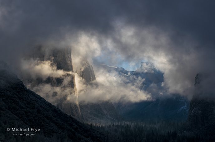
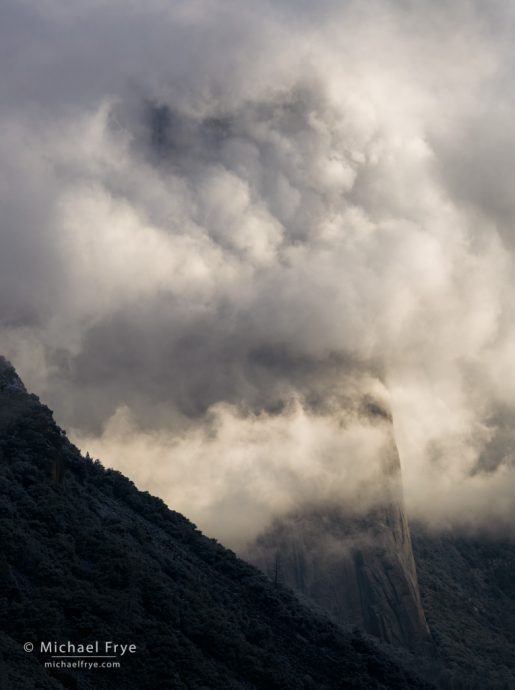
Copious amounts of mist kept blowing up the valley from the west, obscuring the view. We caught occasional glimpses of El Capitan, Cathedral Rocks, and Half Dome, but never saw all three at once. In fact we never even saw all of El Cap at once. But that just seemed to add to the mystery of the scene, and the glimpses we did get were spectacular – especially after the sun rose high enough to backlight the mist around El Cap. One of my favorite moments is shown at the top of the post, with Half Dome and the bottom of El Cap barely visible. And there was another moment where El Cap was almost completely wrapped in mist:
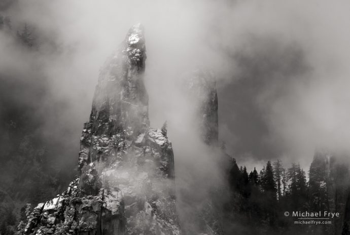
About two hours after sunrise the top of El Cap became buried under a thick blanket of clouds, and seemed unlikely to reappear any time soon, so I decided to head down to the valley. The first thing that caught my eye was the Cathedral Spires poking through the mist. It’s hard to find good views of the spires, but I knew of a spot along the river with a decent view, and headed down there just in time to capture this scene:
I’m glad we decided to take a chance and head up to the valley. I would have been really annoyed with myself if I had gone back to bed, and then later looked at the webcams and seen all that mist!
The forecast calls for a much bigger (and much needed) storm to arrive tonight and linger into Saturday. The snow level is predicted to start at around 5,000 feet, and then drop to between 3,500 and 4,000 feet. Since Yosemite Valley lies at 4,000 feet, that could mean a significant amount of snow on the valley floor – up to a foot – and could also create some difficult driving conditions. Higher elevations could receive two to three feet of snow. We’ll see!
— Michael Frye
Related Posts: Snowy Sunrise; The Big Snow; A Wild Week in Yosemite
Michael Frye is a professional photographer specializing in landscapes and nature. He is the author or principal photographer of The Photographer’s Guide to Yosemite, Yosemite Meditations, Yosemite Meditations for Women, Yosemite Meditations for Adventurers, and Digital Landscape Photography: In the Footsteps of Ansel Adams and the Great Masters. He has also written three eBooks: Light & Land: Landscapes in the Digital Darkroom, Exposure for Outdoor Photography, and Landscapes in Lightroom: The Essential Step-by-Step Guide. Michael has written numerous magazine articles on the art and technique of photography, and his images have been published in over thirty countries around the world. Michael has lived either in or near Yosemite National Park since 1983, currently residing just outside the park in Mariposa, California.




Better to view the storm from below El Cap, as opposed to when you are on the Salathe Wall climb. Been there, done that. :-0
Russ
I’ll take your work for it. 🙂
Is it that you need clouds to clear along with warm temperature after snowing to get mist?
More or less. Even when temps are cold there will usually be mist just as the storm clears. But it won’t last long. If temps are above freezing then the mist can last longer. In my experience, if a storm clears curing the night in Yosemite Valley, and temps then drop below freezing (clear skies usually lead to colder temps at night), there won’t be any mist in the morning. If a storm clears during the night and temps remain above freezing, then there can still be mist in the morning in the meadows and along the river. And – again if the temperature stays above freezing – when the sun hits cliffs, meadows, or trees, moisture will start to evaporate and create more mist, though usually only briefly.
Those are spectacular Michael. Thanks for sharing and thanks for the update. I’m debating driving up Friday to go in the park Saturday morning. But I’m also wondering if going up Saturday for a Sunday morning park visit might actually be better, especially if Saturday is still storming. I’ll be keeping my eyes on NOAA.
Thanks John. It’s still too early to say exactly when this storm will clear. From what I can tell now, I would guess that Sunday morning might be too late for clearing-storm conditions and mist, though there should be lots of snow. Sometime Saturday seems like a better bet. But roads are already a mess in the park, so don’t go up there unless you have 4WD and are have plenty of winter-driving experience. Even then it’s iffy. I’m not sure I’ll be able to get up there in my Subaru. There’s such a thing as too much snow, and this might be one of those times.
Thanks Michael. I was/am concerned about the driving conditions on Saturday which is why I thought perhaps of only driving to El Portal on Saturday afternoon and then the park, early Sunday morning. Do you think getting to El Portal on Saturday would be a problem?
Thanks again.
Getting to El Portal on Saturday via Highway 140 will probably be okay unless the snow level drops lower than predicted. 140 reaches 3,000 feet in Midpines, and the forecast calls for the snow level to get down to 3,500 feet. And the snow level today was already lower than predicted, so it could be lower Saturday as well. Keep an eye on the weather and check Caltrans, as well as the park’s road and weather phone: 209-372-0200.
Thanks Michael. I was thinking/hoping that it would only be rain as far as El Portal. I’m following NOAA and saw the 3500 foot forecast. Ahh, the excitement of the hunt! 🙂
That Cathedral Spires shot looks like it could be Patagonia!
Well Yosemite is pretty spectacular too. 🙂
Breathtaking !!!!!!!!
Thanks for sharing Michael.
We’ll driving up Saturday night trying to photograph Sunday morning.
Hope weather will cooperate.
Love your Yosemite images as always.
As I told John above, Sunday morning might be too late for clearing-storm conditions, but the roads in Yosemite are already a mess, and don’t attempt to go up to the valley anytime soon unless you have 4WD and are an experienced winter driver. Even then I’d think twice.