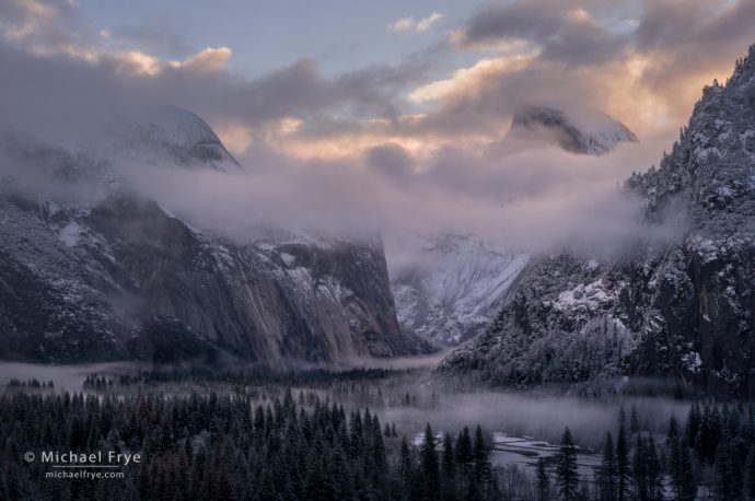
Half Dome, North Dome, and Yosemite Valley at sunrise. I made this image after a light snowfall – accompanied by some beautiful mist – in 2017.
Last Tuesday the Sierra got hit by a big wind storm. Events like this are called “Mono winds” around here, since the wind comes from the east, in the direction of Mono Lake. But similar winds are called “Santa Ana winds” in Southern California, or by various other names around the world. They’re katabatic winds that flow from an area of high pressure to an area of low pressure, accelerating down the leeward slopes of a mountain range. For Mono winds, that means high pressure over Nevada, and low pressure over the Pacific, with the winds flowing from east to west down the long western slope of the Sierra Nevada, accelerating as they descend.
We lost power for about 36 hours, and a large oak fell across our driveway, but we were lucky. Some nearby areas were hit harder, with many homes and vehicles damaged or destroyed by falling trees. Wawona, in the southern part of Yosemite National Park, was devastated. Some neighborhoods are still without power.
The park has been closed entirely to visitors since then. It was scheduled to reopen today, but that reopening has been delayed until this Saturday, January 30th. And it wouldn’t surprise me if that date got pushed back further.
Part of the reason for delaying the reopening is the big storm that’s forecasted this week. We had a very dry autumn, then a few small weather systems in December and early January – then nothing. We finally got a sprinkling of rain last Friday, then a small, cold storm that dropped four inches of snow at our house in Mariposa Sunday night. But overall our rain and snowfall totals are way below average.
Now, however, it looks like we’re in for a deluge. The central Sierra near Yosemite sits right in the bullseye of an atmospheric river that’s expected to arrive tonight, and continue through Friday morning. Rainfall totals might range from five to eight inches over the next three days, and that would translate to many feet of new snow in the high country.
That’s actually really good news. We need the rain and snow desperately. But we’re also eyeing the storm warily, hoping it doesn’t cause more damage. This storm could be accompanied by more strong winds… and then there’s all that snow.
One of the big questions about this atmospheric river is the snow level. Most ARs like this bring in warm, subtropical moisture, so snow levels are often quite high, like 7,000 to 10,000 feet. But this one is colder. Temperatures will be low to start with, and elevations like Yosemite Valley (at only 4,000 feet) could get a foot or more of snow tonight into tomorrow morning. The National Weather Service then predicts that the snow level will rise to around 5,000 feet on Wednesday afternoon and Thursday before dropping back to 4,000 feet on Friday at the tail end of the storm.
I hope they’re right. Some forecasts I’ve looked at predict slightly lower temperatures, which could mean most of all that precipitation would fall as snow (albeit wet snow) in Yosemite Valley. If that happens the Valley might get three or more feet of snow by Friday, which would be fun to see – if I get to see it! That much snow would be paralyzing, because, in addition to all the snow that would have to be cleared from roads and parking lots, that heavy snow would bring down more limbs and trees. So I wouldn’t expect the park to reopen for another few days at least – maybe longer. Even with just (“just”) a foot of snow at the beginning, followed by rain, many limbs are likely to break from all that wet, saturated snow, which could also delay the reopening.
This reminds me of a storm from 2019, when so much snow fell that the park closed the roads. I watched as the Yosemite webcams showed a beautiful clearing storm, with lots of new snow on the ground and in the trees, feeling frustrated that I couldn’t get up there. But I found another nearby spot that had received fresh snow, and made some photographs that I liked, including this one:
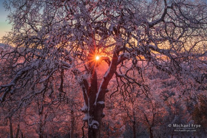
Ice-coated oaks at sunset, Mariposa County, California. Finding this scene was a nice consolation prize after a big snowstorm closed all the roads in Yosemite.
So I hope to get up to the park if it reopens on Saturday. But if not, I can always find someplace else to go and photograph. Either way, I’m happy to see all this rain and snow. I have my fingers crossed that we’ll get lots of it – without further damage.
— Michael Frye
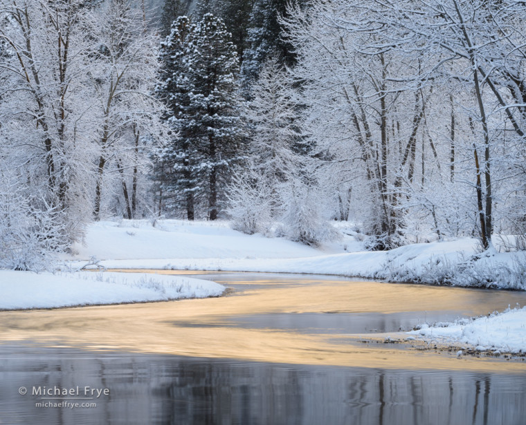
P.S. Photographically, it’s not the amount of snow that matters. I’ve made most of my best Yosemite snow photographs with just a few inches of new snow on the ground. For me, other factors are more important, like having fresh snow still in the trees, and some mist to accompany that snow. It’s fun to see a big snow dump, but all that snow makes it difficult to get around, and it’s not necessarily more photogenic. I’ve included a few snow images here – all made with just a few inches of new snow.
Related Posts: A Monster Storm; Snow in Yosemite Valley
Michael Frye is a professional photographer specializing in landscapes and nature. He is the author or principal photographer of The Photographer’s Guide to Yosemite, Yosemite Meditations, Yosemite Meditations for Women, Yosemite Meditations for Adventurers, and Digital Landscape Photography: In the Footsteps of Ansel Adams and the Great Masters. He has also written three eBooks: Light & Land: Landscapes in the Digital Darkroom, Exposure for Outdoor Photography, and Landscapes in Lightroom: The Essential Step-by-Step Guide. Michael has written numerous magazine articles on the art and technique of photography, and his images have been published in over thirty countries around the world. Michael has lived either in or near Yosemite National Park since 1983, currently residing just outside the park in Mariposa, California.




Hi Michael
Thanks for the all the weather info. I was thinking about sneaking up to Yosemite to get some photos, but I will wait for a bit longer.
You’re welcome Gina.
Thank you for translating what has been and will be happening, Michael, and giving us the heartening news that I don’t need to be there when there’s lots of snow in order to get good photos. I’ve been watching the predictions for this storm w/ an ache in my heart that I can’t get there until at least Sat. Good to know in advance that it may be longer. Best to you and the Park!
You’re welcome Joolz. There doesn’t have to be much snow, but it does make a big difference whether it’s fresh snow or not.
I understand completely. We haven’t had nearly enough snow over here in the Tetons. For us in Teton Valley ID the mountain snow is very important to our farmers (you know, those potatoes guys and gals) need lots of melting snow in the spring and early summer since we rarely get any rain in the late summer. But snow (heavy or powder, measured in feet or inches) can create some interesting photo, as you show in this blog.
Well I hope you get some snow out there Randy – not just for the potatoes. 🙂
Michael, I am pleased to hear that you are safe. I hope that your neighbours are safe too. I was aware that there had been a wind storm, but did not realise how severe it was until receiving your email. I have seen some of the photos and see that there is significant damage. We have had severe floods in the UK. I have seen on the Yosemite webcams that the snow has arrived. Hopefully you get chance to see some of it. I have found even frost on leaves can create some lovely photos. Take care and stay safe.
Frost can be great. Any change in weather or other conditions can create opportunities.
Thank you for posting updated weather conditions with your assessment of landscape photography potential. I’d like to sneak into the valley before the Firefall crowd and shortly after the heavy snowfall completes. Maybe February 7-11 or so. Any input?
You’re welcome Alan. I have no idea what the conditions will be like then, so no real input to offer I’m afraid. Since the park won’t reopen until at least Saturday, you could look for another storm that might bring fresh snow. But snow has become a thing in Yosemite now, so anytime it snows lots of photographers descend on the Valley. It’s not as bad as Horsetail, perhaps, but…