In the Moment:
Michael Frye's Landscape Photography Blog
by Michael Frye | Jan 8, 2014 | Announcements
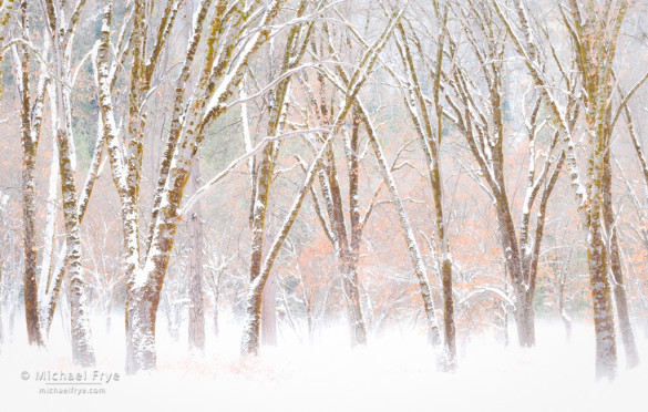
One of my top ten images: Snowy black oaks, late autumn, Yosemite NP, CA, USA
Part of the reason for putting together my top ten photographs of the year was to submit the collection to Jim Goldstein’s blog project – a collection featuring the top images of 2013 from a wide range of photographers. He had a tremendous response this year, with over 300 submissions. If you’re looking for some inspiration, or just want to see some beautiful photography, this is a great list to peruse. I haven’t seen everything yet, so this is by no means a comprehensive selection, but here are some entries that caught my eye and feature some excellent work:
(more…)
by Michael Frye | Jan 4, 2014 | Announcements, Best Images of the Year
The votes are all in and counted, and here are my top ten photographs of 2013!
We had truly an amazing response this year: 396 people looked through my initial selection of 49 images and posted their picks here on the blog, Facebook, Google+, Twitter, and by email. A big thank you to everyone who took the time to look through these photographs and voice your opinions! I also really appreciate all the kind words expressed along with the votes. I wish I could respond to every comment, but please know that I’ve read them all and am very grateful for all your support. And last but not least, many thanks to my wonderful assistant Claudia who tallied all those votes!
To express our gratitude to all of you we’ve decided to give away another print to one of the voters. We assigned each person who voted a number, and used a random number generator to pick the recipient. And the winner is… Judy Heiser! Judy will receive a signed, numbered, matted 16×20 print of her choice from among the 49 original selections. Congratulations Judy!
So here’s the list of the ten images which received the most picks, and the number of votes they each received:
(more…)
by Michael Frye | Jan 3, 2014 | Announcements
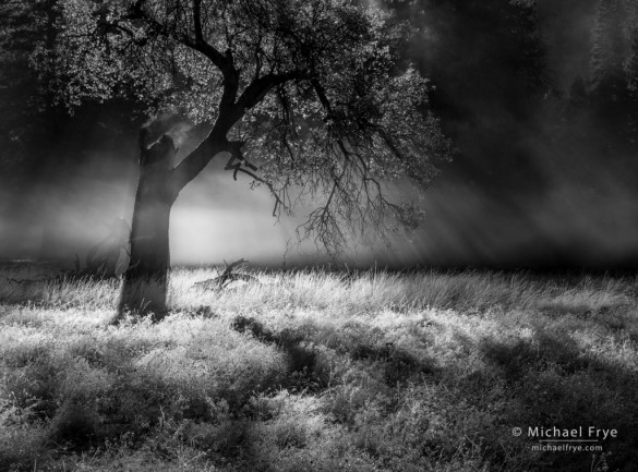
41. Mist, sunlight, and a California black oak, Yosemite
Just a reminder that if you want to vote for your favorite images of mine from 2013 the deadline is midnight tonight, Pacific time. And to all of you who have already voted – thank you very much!
— Michael Frye
by Michael Frye | Jan 1, 2014 | Announcements
Happy New Year! I hope you’ve recovered from your New Year’s Eve celebrations. 😉
Like champagne, Times Square, and Auld Lang Syne, it’s become a New Year’s tradition on this blog to pick out my best images from the past year, and once again I’m inviting you to help make these difficult choices. I’ve posted 49 of my best photographs from 2013 below, in chronological order. After you look through these please post a comment listing your ten favorites. (Click on the images to see them larger.) Once the votes are in I’ll put the top ten on this blog, and submit the finalists to Jim Goldstein’s blog project, where he’ll be showcasing the best images of the year from over 100 photographers. The voting deadline is Friday, January 3rd, at midnight Pacific time.
As always, I reserve the right to override the votes if one of my favorites gets panned. But I have yet to exercise this power — the last three years I went with the votes because, well, we’re all better at judging other people’s photographs than our own.
Thanks for your input — I appreciate your help!
—Michael Frye
(more…)
by Michael Frye | Dec 31, 2013 | Announcements
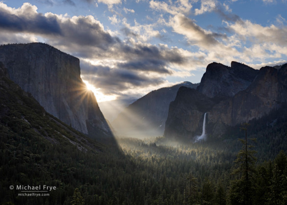
Sunbeams from Tunnel View, spring, Yosemite NP, CA, USA
Happy New Year everyone! To all my readers, thank you so much for your support during the past year. Your participation makes writing this blog fun. I have lots of exciting plans for this blog, and look forward to another great year in 2014!
And don’t forget, tomorrow I’ll be posting the nominees for my best photos of 2013, and you’ll get a chance to vote for your favorites and help me pick the top ten. The image above was the top vote-getter from two years ago.
— Michael Frye
(more…)
by Michael Frye | Dec 30, 2013 | Announcements
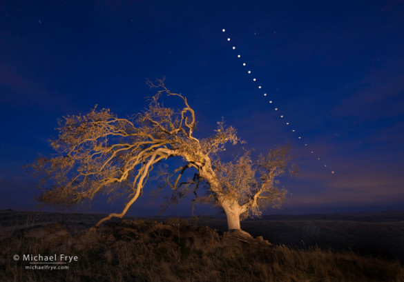
Oak tree and lunar eclipse sequence, Mariposa County, Sierra foothills, CA, USA
One of my most popular posts this year was a recent one, called Moonstruck. This article focused on how to capture moonrise and moonset photographs, with a discussion about how to predict the moon’s movements, and apps that can help with figuring out the precise position of the sun and moon.
While the Moonstruck article focused on photographing moonrises and moonsets, I’ve also written about photographing by moonlight. Tips for Photographing Lunar Rainbows delves into the specifics of moonlight photography: camera settings, shutter speeds, and how to focus in the dark. And in another post from 2012 I described the experience of photographing lunar rainbows in Yosemite, first with the crowds of photographers in Cook’s Meadow, then along the Upper Yosemite Falls Trail. And then late last year I wrote about my most memorable New Year’s Eve, and how that inspired me to make a photograph of the Three Brothers by moonlight.
(more…)
by Michael Frye | Dec 29, 2013 | Announcements
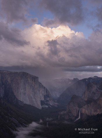
Rain squall over Yosemite Valley from near Old Inspiration Point, Yosemite
Photography encourages us to go to new places, and to be out during the most beautiful times of day when others are asleep or eating dinner. And sometimes – for me anyway – getting to those places can turn into a bit of an adventure.
Last April, on Easter Sunday, Claudia and climbed over 2,000 feet in elevation through rain squalls toward Yosemite’s Old Inspiration Point. We never actually made it there, but we found another good spot nearby, and had a great adventure, as described in my post A Harebrained Idea.
In August, the Rim Fire broke out west of Yosemite. The fire spread rapidly, expanding into Yosemite, and eventually becoming the third-largest fire recorded in California.
I knew this was a big event in the history of Yosemite, so I turned my attention to photographing the fire. During my first attempts I stayed close to the road, as I described in this post. But later Claudia and I made an epic bushwhack to a dome near the Tioga Road, where I captured a panorama of the fire at dusk, shown below.
In my original post about this day I actually didn’t go into much detail about the bushwhack. I’d visited this dome once before, many years ago, to photograph a shapely Jeffrey Pine visible from the road. I remembered it as being a tough hike – only about three miles, roundtrip, but with lots of brush, and clambering over rocks. Yet this seemed like the best place to get a view of the Rim Fire. We decided to go for it, hoping the trip wasn’t as bad as I remembered.
(more…)
by Michael Frye | Dec 28, 2013 | Announcements, Reviews
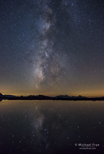
Milky Way reflected in an alpine lake, Yosemite, captured with the Nikon D800E
I don’t often write about equipment, but in August I had a chance to test the Nikon D800E, and since it’s such a good camera for landscape photography I decided to share my thoughts about it. In terms of image quality, this camera is hard to beat unless you jump into the super-expensive realm of medium-format digital cameras.
There is, however, a new camera on the market that may prove to be a worthy competitor to the D800: the Sony A7r. This is a mirrorless camera with a 36-megapixel full-frame sensor. In fact it’s probably the exact same sensor that’s in the D800E, but in a smaller, lighter, and less-expensive package. DxO Mark rated the Sony sensor equal to the D800, and just a point below the D800E.
Unfortunately, hardly any lenses are available yet for this camera. As I write this I think only two lenses are shipping, a 35mm f/2.8, and a 55mm f/1.8, though more will be coming within the next six months or so. You can use Sony’s E-mount lenses for it’s NEX cameras with the A7r, but you’ll get serious vignetting. You can also buy adapters that will let you mount a variety of other lenses, including Zeiss, Nikon, Canon, and others. However, with most adapters you’ll lose the ability to autofocus (or if not, the performance will suffer), and possibly the automatic diaphragm as well. The D800 or D800E are still the best bets if you want a lot of megapixels with a great variety of fully-compatible lenses and accessories.
(more…)
by Michael Frye | Dec 27, 2013 | Announcements, Digital Darkroom
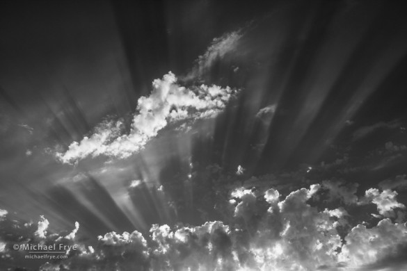
Sunbeams, Mariposa County, CA, USA
Throughout 2013, nothing generated more comments and passionate discussion than my posts about Adobe’s Creative Cloud. As most of you know, Adobe announced in May that it would no longer offer Photoshop and its other Creative Suite applications with a perpetual license. They became available by subscription only, and, at the time, with a rather steep monthly fee of $20 per month for an individual application.
In June I wrote My Thoughts on the Adobe Creative Cloud, which covered my initial reaction to this announcement. Since then some things have changed. Notably, Adobe lowered the monthly subscription rate to $9.99 per month for Photoshop and Lightroom together. At first they offered this rate only to people who already owned a license to Photoshop CS3 or later. Then they offered the package to everyone. I finally decided to subscribe, despite some misgivings; I wrote about my reasons here.
This Lightroom-and-Photoshop package is still available for $9.99 per month (with a one-year subscription) until December 31st. After that? Well who knows. I have a feeling Adobe could be offering similar deals in the future, but no guarantees!
2014 should be an interesting year. Will Adobe make Lightroom available by subscription only? Let’s hope not! Will other software companies move to a subscription-only model? Or will someone seize the opportunity created by all the ill-will toward Adobe and offer a true competitor to Photoshop – with a perpetual license? Stay tuned.
— Michael Frye
Did you like this article? Click here to subscribe to this blog and get every new post delivered right to your inbox!
Michael Frye is a professional photographer specializing in landscapes and nature. He is the author or principal photographer of The Photographer’s Guide to Yosemite, Yosemite Meditations, Yosemite Meditations for Women, and Digital Landscape Photography: In the Footsteps of Ansel Adams and the Great Masters. He has also written three eBooks: Light & Land: Landscapes in the Digital Darkroom, Exposure for Outdoor Photography, and Landscapes in Lightroom 5: The Essential Step-by-Step Guide. Michael written numerous magazine articles on the art and technique of photography, and his images have been published in over thirty countries around the world. Michael has lived either in or near Yosemite National Park since 1983, currently residing just outside the park in Mariposa, California.
by Michael Frye | Dec 26, 2013 | Announcements, Digital Darkroom
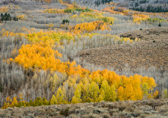
Aspen hillside, Tioyable NF, CA, USA (processed with Lightroom 5)
In April Adobe released the beta version of Lightroom 5, and the full shipping version came out in June. While the jump from Lightroom 4 to 5 wasn’t as big as some previous upgrades, there were some significant improvements, notably the Advanced Healing Brush and the Visualize Spots options for the Spot Removal Tool.
I shared my thoughts about all the changes in the post Lightroom 5 Beta from April. Since then I’ve used the Advanced Healing Brush a lot, and have actually found it to be even more helpful than I initially thought. It does take some practice to get the most out of this tool, but now I do almost all of my retouching in Lightroom, and rarely use Photoshop. This allows me to keep a completely non-destructive workflow, and means that I’ll never have to do the retouching for any of these images again (as I might if I used Photoshop for retouching and ever had to go back and make a change to the Raw file). Very nice.
(more…)


