Yosemite Photo Conditions
by Michael Frye | Feb 26, 2014 | Yosemite Photo Conditions
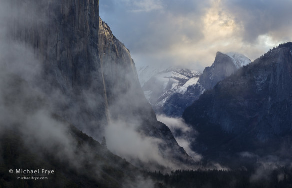
Clearing storm at sunrise, Tunnel View, Yosemite NP, CA, USA
In our extreme California drought, any potential precipitation is big news. This week two storms are forecast to reach the Sierra Nevada: one tonight, and another, stronger system on Friday, continuing into Saturday. While these are colder storms than the last ones, it doesn’t look like Yosemite Valley will get any snow. The snow level is expected to drop to 4,500 feet on Saturday night, just above the valley floor (at 4,000 feet), so it’s possible the valley could get an end-of-storm dusting if the snow-level predictions are a little off. But lower elevations should get a couple of inches of much-needed rain, and the high country could get over two feet of snow – a very welcome addition to the snowpack.
While the window of best light on Horsetail Fall has passed, any precipitation brings the potential for a photogenic clearing storm. Based on the forecast, it looks like we’ll see some clearing tomorrow, and again on Saturday or Sunday (or maybe both). We’re approaching the best time of year to photograph Tunnel View and Valley View (a.k.a. Gates of the Valley), because the late-afternoon light is balanced between El Capitan on the left and Cathedral Rocks on the right. If a storm clears late in the day that will create ideal conditions at both of those classic views. Of course I describe both of these spots, and many others, in The Photographer’s Guide to Yosemite, available as both a softcover book and iOS app.
(more…)
by Michael Frye | Feb 18, 2014 | Yosemite Photo Conditions
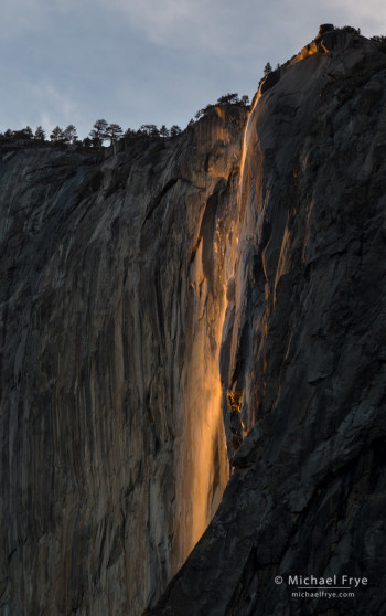
Horsetail Fall just before sunset, Sunday evening, 5:28 p.m.
Yosemite got some showers on Saturday night, which helped to add a little water to Horsetail and create a decent flow – below average, but probably better than anything I’ve seen the last two years.
Sunday evening a workshop student and I joined the throngs of photographers near the El Capitan picnic area. Some thin clouds muted the the light a bit, and then thicker clouds cut the light off entirely just before it would have reached its peak intensity and color, and before the cliff behind the fall was in complete shade. But Horsetail still put on a good show, as you can see from the accompanying photo, made at 5:28 p.m.
Unfortunately the little boost in water level from Saturday’s showers probably won’t last long, and a hoped-for storm tonight and tomorrow now looks like it will bring only a slight chance of showers. I think Horsetail will keep flowing for at least the next week, but the flow will probably be pretty meager. Still, it doesn’t take much. With a clear sunset even a little bit of water can turn into a strip of neon orange. I’d guess the water flow will be similar to 2012; you can see what that looked like in this post from that year.
It now looks like the rest of February is likely to be dry. We really need a miracle March!
— Michael Frye
Related Posts: Another Clearing Storm, and a Horsetail Fall Forecast; Quick Horsetail Update
(more…)
by Michael Frye | Feb 11, 2014 | Yosemite Photo Conditions
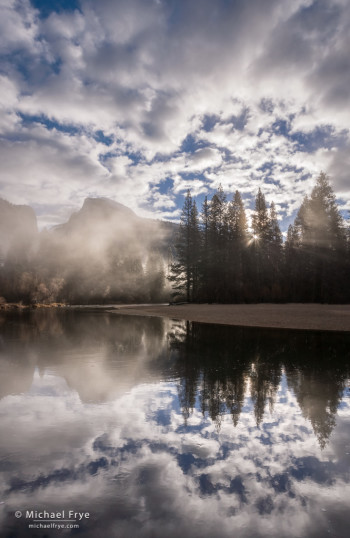
Misty sunrise, Half Dome, Merced River, and clouds, from yesterday morning
Northern California received some desperately-needed rain over the weekend. Most of that rain fell further north, so while Yosemite Valley got around 2.6 inches of rain, Blue Canyon, along Interstate 80 west of Lake Tahoe, got over 9 inches. But I’m not complaining. I’ll take whatever we can get, and those areas further north need the rain just as much as we do.
Like the last storm, this one also had a good sense of timing, clearing just before sunrise Monday morning. I rose early and photographed at several locations in Yosemite Valley, but my favorite image was this one of Half Dome from along the Merced River. I’ve posted other sunrise images from this spot before, but the cloud formations above Half Dome yesterday were exceptional.
The snow levels with this system were high, above 8,000 feet most of the time. I haven’t been able to find snow totals for Tuolumne Meadows, but Mammoth Mountain got two to three feet of snow, and Tuolumne probably got similar amounts.
The waterfalls in Yosemite Valley got a big boost from this storm. Their flow will diminish as the immediate runoff from the storm dissipates, but that new high-elevation snowpack will help feed the waterfalls for awhile, and we should see near-normal water flow for at least the next month or so.
(more…)
by Michael Frye | Feb 4, 2014 | Yosemite Photo Conditions
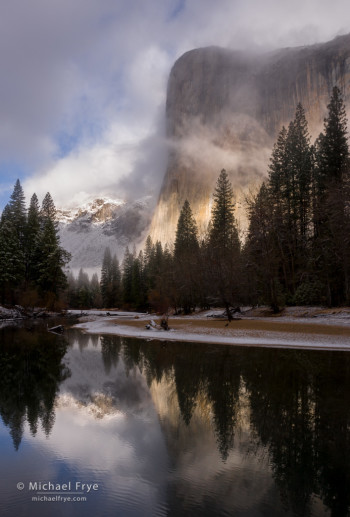
El Capitan and the Merced River during a clearing storm, Friday morning, Yosemite
A clearing storm in Yosemite Valley can be a memorable event, but not all clearing storms are equally photogenic. Some clear gradually, while others finish abruptly and spectacularly. Some storms clear at night, some in the middle of the day, but for photography you’d like the storm to clear just before sunrise or sunset.
Last Thursday, Yosemite Valley got two inches of rain, the first real precipitation in almost two months. Higher elevations got snow, and the temperature dropped enough to give the Valley a slight dusting at the tail end of the storm. The main part of the storm cleared around midday on Thursday – not the best time for photography, though still beautiful. But then showers resumed Thursday night, with the last of them moving through just before sunrise. Perfect timing.
My two brothers were visiting from Washington State, and the three of us rose early, drove up to Yosemite Valley, and headed for one of my favorite spots along the Merced River. The sun broke through the clouds and illuminated El Capitan briefly before the fog thickened and all the cliffs disappeared. But after about ten minutes El Cap re-emerged, the sun broke through, and we were treated to a classic Yosemite clearing storm. The first photograph here is probably my favorite from the morning, but I’ve posted a couple more images below, including a later image from Tunnel View – still a photogenic spot at 10:00 a.m.
(more…)
by Michael Frye | Jan 28, 2014 | Yosemite Photo Conditions
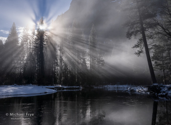
Sunbeams and mist along the Merced River, Yosemite
For many places in California, 2013 was the driest year on record. And so far this winter (our usual rainy season) has brought almost no precipitation. January has brought a procession of sunny days, with temperatures in the 60s or even low 70s at my house at 2700 feet in the Sierra foothills. It’s pleasant weather, but weird, and a little scary, as it seems like it will never rain again.
But finally the forecast is calling for rain and higher-elevation snow this week. It’s not supposed to be a big storm, but we’ll take what we can get. The main pulse of this system is due to arrive Thursday, but showers might linger into Friday or even Saturday. Snow levels are expected to stay at around 7,000 feet on Thursday, but may drop to 4,000 feet on Saturday, so it’s possible, though not likely, that Yosemite Valley could get a dusting of snow.
(more…)
by Michael Frye | Jan 19, 2014 | Yosemite Photo Conditions
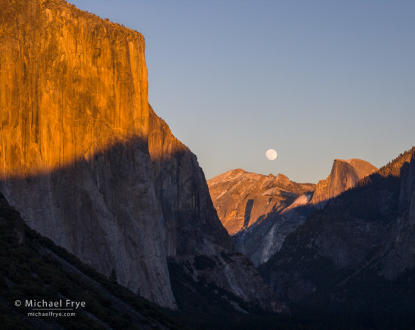
Moonrise from Tunnel View, Yosemite NP, CA, USA
During my Landscapes in the Digital Darkroom workshop last week for The Ansel Adams Gallery we photographed two moonrises, including this one on Tuesday from Tunnel View. The moon appeared right over Cloud’s Rest, between Half Dome and El Capitan, just before sunset – a spectacular sight. I’ve included two versions here: a black-and-white image just as the moon climbed into view (below), and a color version when the moon rose a little higher (above).
(more…)


