Yosemite Photo Conditions
by Michael Frye | Sep 24, 2013 | Yosemite Photo Conditions
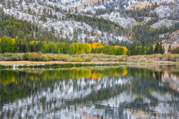
Reflections in North Lake on Sunday morning after a dusting of snow, Inyo NF, CA, USA
Last weekend my wife Claudia and I made our annual pilgrimage to the Millpond Music Festival in Bishop, over on the eastern side of the Sierra Nevada. We had a wonderful time, as usual; this is either the 14th or 15th consecutive year we’ve attended this event, so clearly we love it.
On the drive over we could see some color changes starting to appear in the highest aspen groves, like where Warren Canyon meets Lee Vining Canyon along Highway 120 east of Tioga Pass, and on the higher reaches of the Parker Bench, above the northern end of the June Lake Loop just southeast of Parker Lake.
Saturday evening it sprinkled in Bishop, and further north several inches of snow fell on Tioga Pass and Sonora Pass, temporarily closing both routes. I knew that the nearby upper reaches of Bishop Creek Canyon would likely have a dusting of snow in the morning, and I’d heard that the colors were already changing up there, so I rose early Sunday and drove up to North Lake before sunrise.
(more…)
by Michael Frye | Sep 5, 2013 | Yosemite Photo Conditions
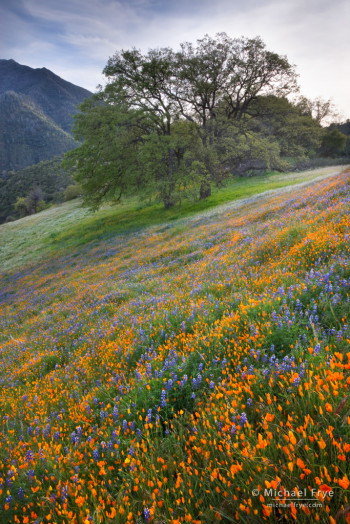
Poppies, lupine, and oaks blooming in an area burned by the 1990 A-Rock Fire, near El Portal, CA (photograph from April 2009)
Yesterday the Rim Fire reached an estimated 237,341 acres in size. That makes it the 4th-largest fire in California since they started keeping records in 1932. It has long since passed the record for the largest fire in the recorded history of the Sierra Nevada. Firefighters continued to make good progress, with containment at 80% as of last night. Even full containment doesn’t mean that the fire is out; it will continue to smolder until the first significant autumn rain or snowfall. But it will mean that firefighters don’t expect the fire to jump their containment lines and spread further.
Since the fire seems to be winding down, it might be a good time to look at some of the long-range consequences of the fire, and put it into perspective in relation to fire management, and the history of fire in this region. I’m not an expert on these matters, but several people who are experts present their views about the causes and consequences of the fire in this New York Times piece. The article includes a striking graph showing the effects of fire suppression during the last 150 years, and links to several other relevant articles. This piece from Wired describes the range of possible outcomes for the burned forest areas, and another article from SFGate covers the reasons why the fire suddenly exploded and burned 90,000 acres in two days.
As I said, I’m not an expert on fire management, but I have seen many fires during my years in and around Yosemite. I have vivid memories of the A-Rock and Steamboat fires of 1990, which closed most of the park for three weeks, and devastated the community of Foresta near the park’s western boundary. My wife Claudia and I lived in Yosemite Valley then, and she was nine months pregnant when the fires started. When she went into labor we had to get special permission to drive through the fire zone to the hospital in Sonora.
(more…)
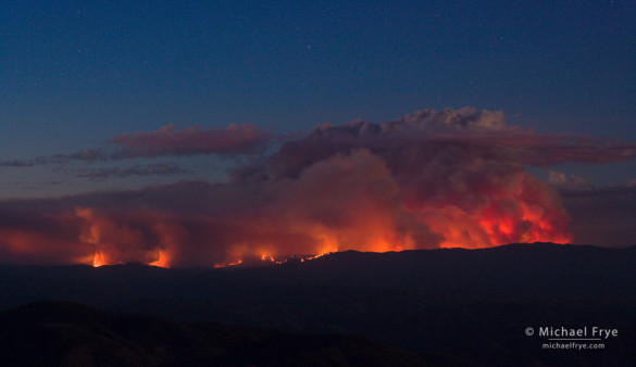
by Michael Frye | Sep 3, 2013 | Yosemite Photo Conditions
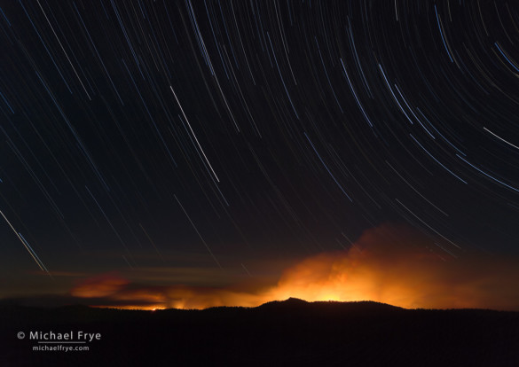
Star trails over the Rim Fire, 8/24/13, Yosemite National Park
On Saturday, August 24th, Claudia and I hiked cross-country to a spot near the Tioga Road with a view of the Rim Fire. I’d picked out this spot, and the route to it, using topographic maps and Google Earth, but you never know until you try it how difficult the route will be, or whether you’ll really be able to find an unobscured view. Fortunately, the hike turned out to be easy, especially compared to our epic bushwhack from two nights earlier. And the view was impressive. The edge of the fire was about six miles away, but the smoke plume was so vast that I couldn’t fit it all in with a 17mm lens.
As the sun went down, I made a series of images of the smoke and fire, some of which are included below. When the sky got dark enough, I set my interval timer to make a series of exposures, each one-minute long, that I could then merge into a star trail sequence. I made about 80 exposures altogether, so the total time for the sequence was about 80 minutes. I then merged the images in Photoshop by setting all but the bottom layer to the Lighten blending mode. You can see the final, merged sequence above. (Here’s link to a post that explains a bit more about this image-stacking technique for star trails.)
(more…)
by Michael Frye | Aug 29, 2013 | Announcements, Yosemite Photo Conditions
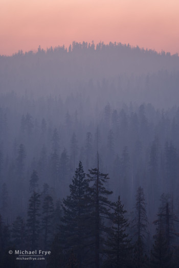
Pastel-colored smoke from the Rim Fire at sunset, 8/26/13, Yosemite NP, CA, USA
I’ve been spending every spare moment photographing the Rim Fire, but I’ve finally had a chance to process some images. I made this photograph Monday evening, as smoke spilled over from the Tuolumne watershed into the Merced watershed near Yosemite Creek, creating a layered view of pastel-colored trees.
The Rim Fire has become the largest fire in the recorded history of the Sierra Nevada, though undoubtedly much larger fires regularly swept through these mountains before Europeans arrived here. At 192,737 acres, the Rim Fire is also the sixth largest in California history, and seems almost certain to pass the Witch Fire (197,990 acres) for fifth place.
The fire’s growth has slowed considerably. Estimated containment for the Rim Fire is 30%, which represents a lot of progress for firefighters within the last few days.
Highway 120 west of Yosemite remains closed indefinitely. Within the park, Highway 120 is temporarily closed from the park’s western boundary to Yosemite Creek. This means that you can’t drive from Yosemite Valley over Tioga Pass to Lee Vining and Mono Lake (or vice versa). You can reach Tuolumne Meadows, Tenaya Lake, etc., by taking another route to Lee Vining, and driving into the park over Tioga Pass, but you’ll have to turn around at Yosemite Creek and leave the park via the same route.
(more…)
by Michael Frye | Aug 23, 2013 | Yosemite Photo Conditions
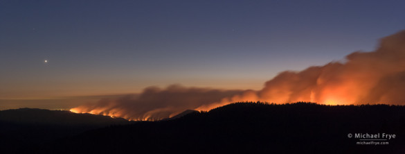
Looking west at the Rim Fire from near the Tioga Pass Rd. at dusk, with Venus setting, 8:57 p.m., 8/22/13, Yosemite NP, CA, USA
Last night my wife Claudia and I made an epic bushwhack to a dome near the Tioga Pass Road with a view of the Rim Fire. This is a two-image stitched panorama, looking west toward the Central Valley, with Venus setting on the left. Each frame was 30 seconds long.
This fire is growing at an alarming rate. It doubled in size yesterday, and as of this morning it was listed as over 105,000 acres. That already makes it the 19th-largest fire in California history. The Rim Fire crossed the western boundary of Yosemite National Park yesterday between Camp Mather and Eleanor Lake.
So far most of Yosemite hasn’t been affected. The smoke has been blowing north, away from the park. The biggest affect is the closure of Highway 120 outside the park, but there are alternate routes.
Let’s hope that growth slows down!
— Michael Frye
(more…)
by Michael Frye | Aug 22, 2013 | Yosemite Photo Conditions
The Rim Fire at dusk, 8/21/13, from a viewpoint near Mariposa
Wildfires are common around here in summer and fall. Fire means smoke, and photographers visiting Yosemite during a fire sometimes complain about the smoke. I’ve learned to roll with it. When smoke spoils my plans, I make a new plan. That attitude actually applies to any photographic situation. I can’t control the weather, so I adapt to whatever conditions I find.
On Tuesday afternoon the clouds over the Sierra were spectacular, so Claudia and I headed up the Tioga Road to try to catch some of those clouds lighting up at sunset. As we approached Siesta Lake, however, we became immersed in smoke from the Rim Fire, and realized that the smoke would block the sunset light. So I went to Plan B, my standard plan in these situations, which is to photograph the fire itself.
(more…)


